Chalvey and Upton-Cum-Chalvey
Chalvey is part of Slough, and is the place I live in at the time of writing this note.
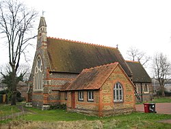
I live in a council flat nearly opposite St Peter's Church. The latter sometimes hosts jumble sales, and second-hand book sales......
RS
| Chalvey | |
| Buckinghamshire | |
|---|---|
 St Peter's Church | |
| Location | |
| Grid reference: | SU965795 |
| Location: | 51°30’24"N, 0°36’37"W |
| Data | |
| Post town: | Slough |
| Postcode: | SL1 |
| Dialling code: | 01753 |
| Local Government | |
| Council: | Slough |
| Parliamentary constituency: | Slough |
It was first recorded in 1217 by an Old English word meaning "Calf Island", from Cealf meaning calf. As the name implies, Chalvey lies low on the plain of the River Thames, and there may have been enough of a rise for an island to stand above the slough (marsh) from which the later town takes its name.
As Slough developed, Chalvey developed as a working-class community of small terraced houses. Nonconformist churches were established starting with the Congregationalists in 1806.[1]:37
In 1849, the Slough to Windsor railway was built, passing through the middle of Chalvey. A halt was opened by the Great Western Railway in 1929 but closed the following year.[2]
At some point between 1850 and 1880, a local legend developed about the "Chalvey Stab Monkey" involving an organ grinder and a stabbed monkey; the first person to get blind drunk on the anniversary of the monkey's funeral is declared "Mayor of Chalvey". Traditionally, residents of Chalvey have been known as "stab-monks".[1]:40 A long-standing local joke suggests that Chalvey's main industry is in the Treacle Mines. On occasion, this has been taken to be a reference to the local sewage works.[3]
It was stated on the "Immigration - How We Lost Count" edition of the BBC1 documentary Panorama on 23 July 2007 that Chalvey is severely overcrowded, and that most of its residents are immigrants and members of ethnic minorities. Chalvey has a large Asian population.[4]
The first recorded Lord of the Manor of Chalvey was recorded in the year 1502. The current Lord of Chalvey, Christopher Johnson, lives in the United States.
References
- ↑ 1.0 1.1 Fraser, Maxwell (1973). The History of Slough. Slough Corporation.
- ↑ Hunter, Judith; Hunter, Karen (1992). Around Slough in Old Photographs. Alan Sutton Publishing. p. 53. ISBN 978-1845884628.
- ↑ Slough Museum (2003). The Changing Face of Slough. Breedon Books. p. 58. ISBN 978-1859833155.
- ↑ 2001 - Key Statistics Slough Borough Council Chalvey WardSlough
Upton-cum-Chalvey
| Upton-cum-Chalvey | |
| Buckinghamshire | |
|---|---|
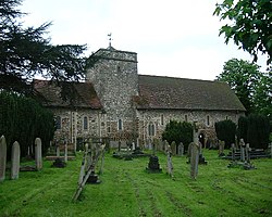
 St Laurence in Upton | |
| Location | |
| Grid reference: | |
| Data | |
| Post town: | Slough |
| Postcode: | SL1 |
| Dialling code: | 01753 |
| Local Government | |
| Council: | Slough |
| Parliamentary constituency: | Slough |
Upton-cum-Chalvey is an ancient parish in the Stoke Hundred of Buckinghamshire that now forms the centre of Slough. As its name suggests, the parish originally comprised the separate villages of Upton and Chalvey.
History
The Domesday Survey of 1086 refers to Upton, and a wood for 200 pigs, worth £15. Upton took its name from its situation at the top of the slope from the river terrace — the various levels in the area having been formed in the Ice Age.
In 1894 a new civil parish of Slough was formed from part of the civil parish of Upton-cum-Chalvey, which was reduced in size as Slough expanded until it was entirely annexed by 1901. The ecclesiastical parish is still known as Upton cum Chalvey.[1]
Church
Upton's Norman Church, St Laurence's, was the marriage place (7 May 1788) and burial place (1822) of Sir William Herschel (in whose memory there stands a newly erected stained-glass window depicting Uranus, which he discovered, and other planets), and the burial place of Charles Hatchett who discovered niobium.
Other buildings
Upton Court is the name of the original manorial buildings for the parish of Upton. Parts of Upton Court were built in 1325. In the 19th century, it was a seat of the Burton family and was, up until March 2010, home to the Slough Observer newspaper. The nearby Slough Grammar School changed its name in 2013 to Upton Court Grammar School.
The Mere is a 19th-century half-timbered building, built in 1887 by the grandson of Richard Bentley, is now the head office of the National Foundation for Educational Research. Long Close School was established in the area in 1940.
Upton Park
Upton Park forms one of Slough's earliest planned estates. Laid out in 1842, the grounds (a public park as Herschel Park since 1949) are believed to have been designed by Joseph Paxton.[2]
In 2011, the nine-acre Grade-II-listed park and nature reserve underwent a restoration project to re-establish the area to its former Victorian glory with a lottery grant of £2.7m from the Heritage Lottery Fund.[3] Friends of Herschel Park, a local conservation group, was created to manage the restoration, as well as to oversee the design and maintenance of the area.[4] The park regularly holds events for adults and children throughout the year. [5]
References
- ↑ St Mary's Church Slough website
- ↑ p 144, The History of Slough, Maxwell Fraser, Slough Corporation, Slough, 1973
- ↑ Herschel Park - Slough Borough Council
- ↑ The Friends of Herschel Park
- ↑ Whats On - Friends of Herschel Park
Outside links
- Page, William, ed (1925). Victoria County History of Buckinghamshire. Vol. 3. pp. 314–318.
- Friends of Herschel Park Official Website

Comments
Post a Comment